Unfinished Business 2018
A sea kayak journey to the BAARE base site at Nativit East Greenland.
I have harped on about Gino Watkins now for many years, however his exploits have been a significant inspiration for me and over the years have inspired several of us to thoroughly explore the Angmassalik region of East Greenland.
Although much of my regular touring area around Tasiilaq was explored and mapped by Watkins team in the 1930’s, there was still one major area for us to visit and explore.
The site of the original “1930 British Arctic Air Route Expedition base”, Which was established south of Angmassalik Island near the old settlement of Nativit.
For a small group of us, this became the focus of a trip this summer.
The team consisted of Sonja and James and Donna who had been with me on my Lake Fjord expedition in 2016.

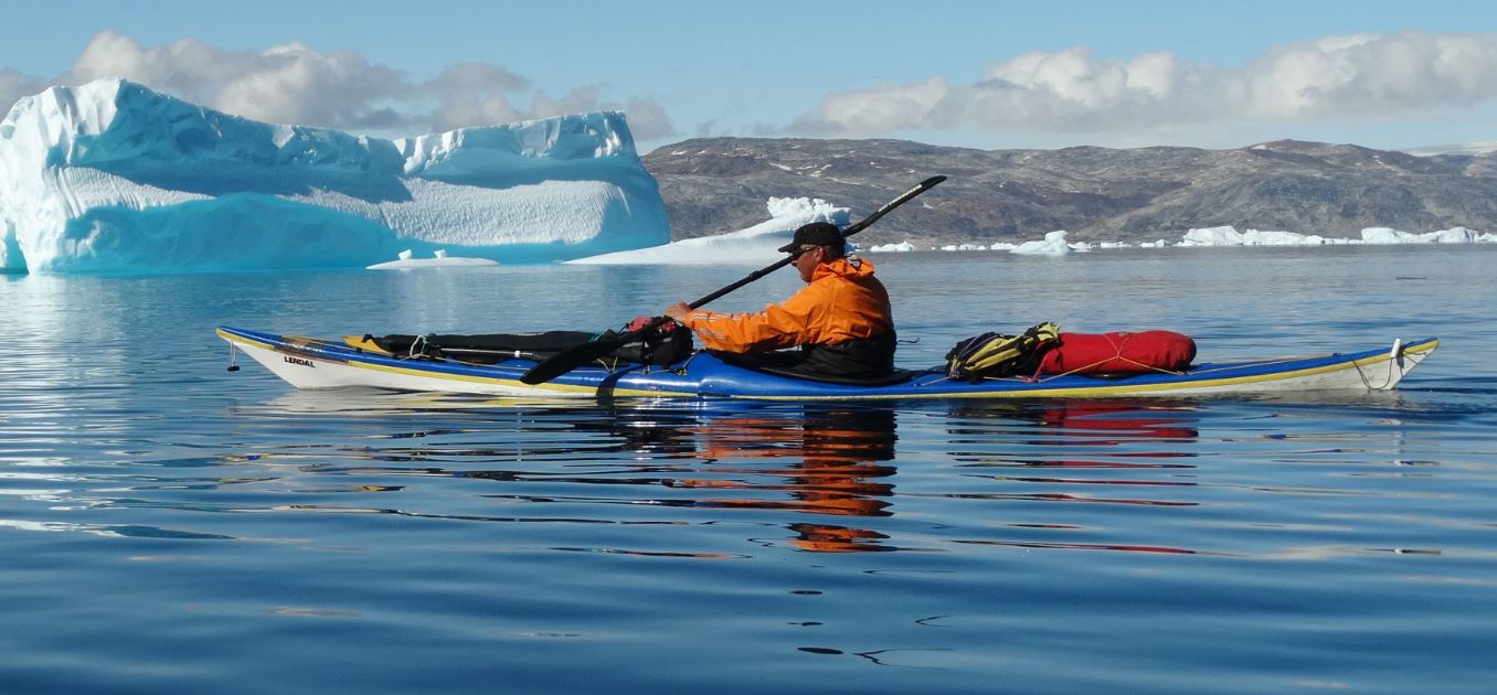
The sea ice had moved out from the coast early this year and although this increased the potential of much greater sea swells, effecting exposed headlands, conditions fortunately remained calm and settled.
We all know the Angmassalik area very well, however from Nativit at the west side of Sermilik fjord, we would be on new and unexplored ground.
Nativit was the site of an old Inuit settlement and comprised of over a dozen large turf houses which would each have housed an extended family.
Several of these (probably during the time of Watkins) were remodelled to have a wooden house inside the walled structure. This remote settlement is mentioned in “Northern Lights” (F S Chapman) and we were keen to stop and see if there was anything interesting or recognisable left.

After what had turned into a rather long day we were pleased to discover a very small (modern day) hunter’s cabin in the channel between Nativit and the outer islands.
Although cramped, this was still a real bonus as it saved us having to do a bear watch that night.
We had, had a bear encounter a few days before (neither party came to any harm) on the west side of Sermilik fjord. Although justifying all our previous night watches it meant bears were definitely in the vicinity.
This area feels extra remote and by now we were on our guard, each of us doing two hour bear watches during the night, which soon becomes exhausting. We were also setting trip lines around our camp at night. James commented that this was the only place he had ever needed to take a gun and a camera with him when venturing off to the toilet.

While exploring that evening we discovered two substantial wooden posts that had been placed vertically in the ground and about 6 meters apart. Although I can’t be certain, we would strongly suspect these were used as the vertical supports for Inuit rope training / kayak agility training / games.
None of us had ever seen anything similar before, but all agreed due to their location in the settlement that there would have been very little other explanation for their purpose.
It was also interesting to think that several of the old wooden huts may well have been built using materials scavenged from the BAARE site when Gino and the team abandoned it in 1931. Wood and timber is a valuable commodity in this area, even now, and an empty hut would soon have been re purposed. The atmosphere is very dry and timber takes a long time to rot.

A late start due to further exploring saw us paddling the final 14 km into the fjord to locate the BAARE base site. The outer coast had been pretty free of ice bergs, however from here on in the fjord was packed with them.
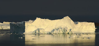
These were some of the largest and most impressive bergs I have ever encountered, and quite why they were here remains a bit of a mystery to us, as conditions and tide didn’t account for their presence.
Dog Island, where Gino tethered his sled dogs before off loading supplies was easy to identify and we landed on the smooth rock slabs where the Quest would have unloaded her cargo in 1930.
After an initial recce, and as we intended base camping for several days, we decided to lug all our kit up to the hut site and establish our camp there.
It was a strange feeling, walking up and down the smooth flat rocks from the kayaks to our camp, thinking of all the times this route would have been trodden in the past. There is a wide uniform band of smooth black rock which is just like a paved path and your eye always goes to it and you end up walking this line, whether you want to or not. I am sure this was also the case in 1930. After all this time we could still see bits of coal that had escaped from a burst or overfull sack and had lain hidden in a rock crevice, unobserved or thought about for over 90 yrs.
That evening we set up our trip line round the tents – if walked through a taught line would pull and activate an audible alarm, this was to give us a heads up, rather than scare any bear away. It’s a simple system I have developed myself and is easy and lightweight to carry in the kayaks.

The next few days were spent soaking up the atmosphere, everyone pretty much did their own thing, mooching about and looking for artefacts. There is very little left to see, however once you trained your eye in the outline of the hut was very clear.
Donna had brought out her copy of “Northern Lights” and we all got a lot of pleasure from identifying the exact spot from which all the original photos were taken.
It made us smile when we realised that several of the shots were very staged and taken from the rocks at the landing site. Understandable I suppose given the heavy camera gear they were using at that time. The back drop to these photos is unchanged and was easy to identify.
There was only one good fresh water source and unbeknown to us we had already found it on our paddle from Nativit into Dog Island. Again it was strange to think of folk inevitably walking the same route we did to get drinking water.
Donna was a real sleuth with her book, even finding the remains of the post (snapped off but still embedded) which held up their original washing line and the metal rings used to anchor the radio mast.
The site is littered with broken bits and pieces, these included :- spent ammo, paper shot gun cartridges, broken beer bottles, medicine bottles, roofing felt, wood, hinges, the remains of the stove, lots of window glass, coal, pottery, wire, electric cable, battery plates, bits of big earthen wear storage jars, dog harness buckles, shoe / boot soles, a bracket from a Seagull outboard motor, various unidentifiable bits of metal work, what looked to be radio parts and most exciting of all bits of broken gramophone records.
Everything was photographed and left on site, apart from the bits of gramophone record which I took and will try and find someone to help identify the songs for me.

It was very noticeable how the growth of any plant life testified to the extreme conditions regularly experienced here.
NW behind our camp was a rocky hill which gave great views in all directions, including out to sea – in the day this was undoubtedly a well visited summit. Watkins would have been checking out conditions and looking for returning boats, planes or sled teams. For us this was a great site to observe and photograph the ice cap, icebergs in the fjord, and locate our route up onto the inland ice.
We spent a day paddling into the head of the fjord to check out the original route used in 1930 to access the ice.
It was an amazing feeling looking up from the beach at the “gully route” and scree which was their start point for any trip inland. However for us at least the way up “Bugbear Bank” as it was affectionately named, is now impassable, as the ice has receded so much, leaving a huge rock moraine and boulder field.
As a result the following day we paddled over to the far side of the fjord to investigate another area we thought might be more promising and one Watkins had used when travelling by dog sled to Isatoq.
Negotiating the colossal icebergs on route was a daunting prospect as we had previously witnessed huge collapses and seen the effect the resulting waves had had on other small bergs in the area – it was certainly not a place to linger.
Interestingly though, these very significant waves didn’t affect the landing site, and our kayaks, like Watkins boats and planes were safely sheltered by the buffer of rocks at dog island..

Reaching the far side we managed to locate a gently sloping tongue of ice which gave us good access from a sandy beach onto the ice cap. We brought the kayaks up to a safe position and secured them with lines before changing from kayak to mountaineering gear.
It was good to explore the area, view and photograph it from the ice and although we didn’t gain any major height by mountaineering standards, it was a fantastic experience.
At the last minute Stephen Spencer Chapman (Freddy S Chapman’s grandson) had been unable to join our expedition, However the family did provide a very unobtrusive plaque acknowledging the 1930 expedition team. We chose a good location overlooking the base site, protected from the elements and secured it to a flat, vertical piece of bed rock.
One overriding memory from this trip was the silence of it all, which was only interrupted by the sound of the huge icebergs rumbling and collapsing behind our camp.
During several days of pottering about and taking photos, it was hard not to notice that the base site is now on a direct transatlantic air route – with several high altitude flights (too high to hear) going overhead every day. Ironic that the very reason Watkins came here was to gather weather information for PANAM Airlines.

One day a local family out hunting stopped at the rock slabs for lunch, inviting us to join them for a meal of cooked seal meat and blubber.
This was a first for several of the team and quite a highlight too.
They were very interested in our kayaks and that we had come to such a remote place, like their ancestors, travelling by kayak – although they used the rocky look out to check on conditions and look for seals, they were completely unaware of the fact that the remains of the base site were there.
Freddy S Chapman’s account of the BAARE is called Northern Lights, so it was a fitting finale that we experienced several great displays of this phenomenon, not least on the final night before we paddled out.

Our journey into Nativit and the BAARE base site felt like such an adventure, all the more so knowing the heritage associated with it and the feeling of being so isolated and “out there”. Remarkable to be again be following in the same steps and standing on ground that had been such a significant part of other people's lives during the 1930s. It's hard to put into words the feelings and emotions associated with this journey. At times you could hear a pin drop. The silence and peace of the place was inspiring and thought provoking. Frequent reflections into what life must have been like to live here during that time regularly crossed our minds. The drama associated with the enormous collapses of ice from the icebergs in the fjord entered our conscious and unconscious sleeping minds on a regularly basis due to their regular roar and thundering.